Potential Islands / Park Expansion on the City of Peoria Shoreline
City of Peoria / Peoria Park District / Corps of Engineers
Meeting at the Rock Island Corps Office
10:30 am Wednesday October 1, 2008
Meeting Notes
Attendees
Plumley, Marshall B MVR
Mike Cox Illinois Waterway Project Office
Nichole McVay Corps Channel Maintenance
John Klingner Corps Channel Maintenance
Wayne Hannel Corps Regulatory
Jane Gerdes
David Wheeler
Craig Hullinger
Hullinger briefed Corps staff on the City plans for the Green Edge Plan and The River Trail Drive Plan. The City Planning Commission, Heart of Peoria Commission, and City Council have all given unanimous approval of these plans. Hullinger provided small scale copies of the plans, and noted that all of the information was on line at http://www.peoriaed.blogspot.com/ under “Green Edge” and River Trail Drive”.
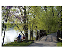
The City of Peoria plans a public “Green Edge” along the river from Water Street to War Memorial Drive. Over time, the existing river edge can be converted to parks, a riverfront drive, and new residential development.
Currently this area is primarily industrial with two marinas and parks. This plan proposes that the entire rivers edge become a linear park with a scenic drive connecting from Water Street north to Grand View Drive, with new homes, additional public park land, and beautification of the area.
The River Trail Drive Plan is part of the Green Edge area and covers the area currently owned by the City, from about 3 blocks north of I-74 north to north of Spring Street. The City is searching for developers now, and has strong interest from quality firms.
The City plans a create quality mixed use development overlooking Riverfront Park, an attractive scenic drive, and quality new park land. This development would help revitalize Downtown, improve the safety and usability of Riverfront Park and provide housing opportunities in a park like atmosphere while minimizing impacts to the park, the surrounding neighborhood, the environment and the ecology of the river.
The new Lakeshore Drive would provide an opportunity to drive overlooking the lake similar to the Grand View Drive. This development would utilize 100 feet of land adjacent to the railroad tracks. The northern 60 feet of land would be used for build quality mixed use development. The southern 40 feet would be used to build a scenic overlook road named River Trail Drive. The road and new housing would extend from the Riverplex parking lot north to Spring Street. There would be three access points: one at Irvine Street, one at Norton Street and one at Spring Street.
To accomplish this development some existing Riverfront Park will be used and some of the park’s amenities will need to be relocated. Soil dredged from the river would be enlisted to create more riverfront parkland.
Environmental Improvements
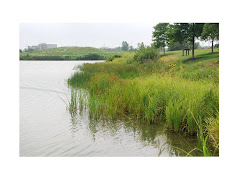
The City wants quality ecological improvement to the River and shoreline, including the existing River Front Park. At present the River’s Edge provided a very steep and unnatural slope to the River. Much of the river’s edge is concrete spoil. The slope is dangerous, and makes access to the River’s edge dangerous.
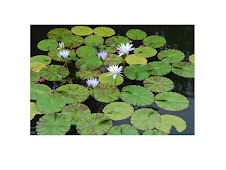
An environmentally well designed new river’s edge could significantly enhance the ecosystem, and return the river’s edge to a more natural condition. Wetlands could be added back into the edge, with improved fish and bird habitat.
Part of the plan involves the creation of additional open space to replace the land taken for the new river front road and housing. This city is requesting assistance from the Corps of Engineers in properly designing and constructing the additional land. From the City perspective, the City would prefer that the Corps design, permit, and build the islands.
Hullinger noted that the Corps had previously asked where the City would like dredge material placed. Hullinger noted that the City had provided a map showing possible locations, which include widening of the existing and proposed park areas along the River’s edge.
The City has prepared several concept plans. One includes the islands, while the other would simply expand and widen the shoreline. The City is open to either approach.
Jane Gerdes noted that the City Public Works Department was working on the Combined Sewer Outfall issue. The plan was consistent with that effort, and all alternatives involved the construction of a very large sewer line from Spring Street south to reduce pollution.
Corps staff provided an overview of the regulatory process and the need for a joint application to initiate permit review by the Corps, IDNR Office of Water Resources and IEPA.Marhall Plumbley described the Corps permitting issues. The Corps does not have funds or authority for this project now. Channel maintenance dredging in the vicinity has been sporadic, with last event occurring in 1988. If that situation changed or the Farm Creek Diversion Channel began encroaching upon the navigation channel, the need for maintenance dredging would be reevaluated. However, based on many years of experience with the river and its dredging needs, the Corps does not see a short term (5-20 years) need for placement of material., and no plans in the near future for additional dredging efforts. The islands could be built much faster if the city would fund the design and construction effort.
The Corps will be constructing a 21 acre island in the northeast corner of the lower lake this year. The Corps is planning an additional approximately 75 acre island. Hullinger suggested that the Corps consider build the 7 acre Peoria Island when the 75 acre island is constructed. When the Corps and State of Illinois begin the design of that lower island, this issue could be revisited. However, given funding constraints at the State and Federal level, that could be a very long time.
NEXT STEPS
Hullinger asked the Corps staff to consider supporting the project. He also asked them to consider designing and constructing the new shore line. He noted that the proposed development has strong local political support, and that the City is working with the State and Federal Legislators to gain support for the development.
More info at:
http://rivertraildrive.blogspot.com/
http://greenedgepeoria.blogspot.com/
http://peoriaed.blogspot.com/


